
A Modified Maximum Entropy Algorithm for Sea-Land Segmentation
Keywords:
Maximum entropy, Remote sensing, Sea land segmentation, Ship detectionAbstract
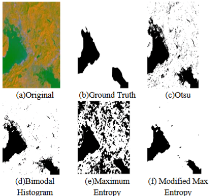
Sea-land segmentation is a key pre-processing step for ship detection from optical remote sensing imagery. Because of waves, illumination and shadows, conventional sea-land segmentation algorithms usually confuse between land and sea. Thus, a new maximum entropy segmentation scheme based on an adaptive threshold is proposed in this paper. Experimental results show that our algorithm has better accuracy compared to many traditional algorithms such as conventional maximum entropy algorithm, Otsu algorithm and bimodal histogram algorithm.
Downloads
References
Roelfsema, C., Kovacs, E. M., Saunders, M. I., Phinn, S., Lyons, M., and Maxwell, P. (2013). Challenges of Remote Sensing for Quantifying Changes in Large Complex Seagrass Environments. Estuarine Coastal Shelf Sci. 133, 161–171.
Chaudhary, D. S. . (2022). Analysis of Concept of Big Data Process, Strategies, Adoption and Implementation. International Journal on Future Revolution in Computer Science &Amp; Communication Engineering, 8(1), 05–08. https://doi.org/10.17762/ijfrcsce.v8i1.2065
Guo, Q., Pu, R., Zhang, B., and Gao, L. (2016). “A Comparative Study of Coastline Changes at Tampa Bay and Xiangshan Harbor During the Last 30 Years,” in 2016 IEEE International Geoscience and Remote Sensing Symposium, Beijing, China, July 10–15, 2016 (IGARSS), 5185–5188.
André Sanches Fonseca Sobrinho. (2020). An Embedded Systems Remote Course. Journal of Online Engineering Education, 11(2), 01–07. Retrieved from http://onlineengineeringeducation.com/index.php/joee/article/view/39
Chen, C., Fu, J., Zhang, S., and Zhao, X. (2019). Coastline Information Extraction Based on the Tasseled Cap Transformation of Landsat-8 OLI Images. Estuarine Coastal Shelf Sci. 217, 281–291.
Wernette, P., Houser, C., and Bishop, M. P. (2016). An Automated Approach for Extracting Barrier Island Morphology from Digital Elevation Models. Geomorphology 262, 1–7.
Wang, D., and Liu, X. (2019). Coastline Extraction from SAR Images Using Robust Ridge Tracing. Mar. Geodesy 42, 286–315.
Cao, K., Fan, J., Xinxin Wang, X., Xiang Wang, X., Jianhua Zhao, J., and Fengshou Zhang, F. (2016). “Coastline Automatic Detection Based on High Resolution SAR Images,” in 2016 4th International Workshop on Earth Observation and Remote Sensing Applications, Guangzhou, China, July 4–6, 2016 (EORSA), 43–46.
Sai, M. P. ., V. A. . Rao, K. . Vani, and P. . Poul. “Prediction of Housing Price and Forest Cover Using Mosaics With Uncertain Satellite Imagery”. International Journal on Recent and Innovation Trends in Computing and Communication, vol. 10, no. 8, Aug. 2022, pp. 36-46, doi:10.17762/ijritcc.v10i8.5666.
Fan, J., Cao, K., Zhao, J., Jiang, D., and Tang, X. (2016). “A Hybrid Particle Swarm Optimization Algorithm for Coastline SAR Image Automatic Detection,” in 2016 12th World Congress on Intelligent Control and Automation, Guilin, China, June 12–15, 2016 (WCICA), 822–825.
Elkhateeb, E., Soliman, H., Atwan, A., Elmogy, M., Kwak, K.-S., and Mekky, N. (2021). A Novel Coarse-To-Fine Sea-Land Segmentation Technique Based on Superpixel Fuzzy C-Means Clustering and Modified Chan-Vese Model. IEEE Access 9, 53902–53919
Rigos, A., Tsekouras, G. E., Vousdoukas, M. I., Chatzipavlis, A., and Velegrakis, A. F. (2016). A Chebyshev Polynomial Radial Basis Function Neural Network for Automated Shoreline Extraction from Coastal Imagery. ICA 23, 141–160.
Vos, K., Splinter, K. D., Harley, M. D., Simmons, J. A., and Turner, I. L. (2019). CoastSat: A Google Earth Engine-Enabled Python Toolkit to Extract Shorelines from Publicly Available Satellite Imagery. Environ. Model. Softw. 122, 104528.
Sun, B., Li, S., and Xie, J. (2019). “Sea-Land Segmentation for Harbour Images with Superpixel CRF,” in IGARSS 2019 - 2019 IEEE International Geoscience and Remote Sensing Symposium, Yokohama, Japan, July 28–August 2, 2019, 3899–3902.
Cheng, D., Meng, G., Xiang, S., and Pan, C. (2016). Efficient Sea-Land Segmentation Using Seeds Learning and Edge Directed Graph Cut. Neurocomputing 207, 36–47.
Liu, X.-Y., Jia, R.-S., Liu, Q.-M., Zhao, C.-Y., and Sun, H.-M. (2019). Coastline Extraction Method Based on Convolutional Neural Networks-A Case Study of Jiaozhou Bay in Qingdao, China. IEEE Access 7, 180281–180291.
Liu W, W., Chen, X., Ran, J., Liu, L., Wang, Q., Xin, L., et al. (2021). LaeNet: A Novel Lightweight Multitask CNN for Automatically Extracting Lake Area and Shoreline from Remote Sensing Images. Remote Sensing 13, 56.
Cui, B., Jing, W., Huang, L., Li, Z., and Lu, Y. (2021). SANet: A Sea-Land Segmentation Network via Adaptive Multiscale Feature Learning. IEEE J. Sel. Top. Appl. Earth Obs. Remote Sensing 14, 116–126.
Tsallis, C. (1988). Possible generalization of Boltzmann-Gibbs statistics. Journal of Statistical Physics, 52, 479-487.
Portes de Albuquerque, M.; Esquef, I.A.; Gesualdi Mello, A.R.; Portes de Albuquerque, M. (2004). Image thresholding using Tsallis entropy. Pattern Recognition Letters, 25, 1059-1065.
Yang T, Jiangde S, Hong Z, Zhang Y, Han Y, Zhou R, Wang J, Yang S, Tong X, Kuc TY. Sea-Land Segmentation Using Deep Learning Techniques for Landsat-8 OLI Imagery. Marine geodesy, 2020,43(2):105-133.
Sea Land Segmentation Public Dataset (https://github.com/zhhongsh/sea-land-segmentation) Last accessed: 16 April 2022
Russell, B. C., A. Torralba, K. P. Murphy, and W. T. Freeman. 2008. LabelMe: a database and web-based tool for image annotation. International Journal of Computer Vision 77(1-3): 157-173.
Modiya, P., & Vahora, S. (2022). Brain Tumor Detection Using Transfer Learning with Dimensionality Reduction Method. International Journal of Intelligent Systems and Applications in Engineering, 10(2), 201–206. Retrieved from https://ijisae.org/index.php/IJISAE/article/view/1310
Haklay, M. and P. Weber. 2008. OpenStreetMap: User-generated street maps. IEEE Pervasive Computing 7(4): 12-18.
Sokolova, M., N. Japkowicz, and S. Szpakowicz. 2006. Beyond accuracy, F-score and ROC: a family of discriminant measures for performance evaluation. In Proceedings of the Australasian Joint Conference on Artificial Intelligence Springer, Berlin, Heidelberg: 1015-1021.
Nobuyuki Otsu (1979). "A threshold selection method from gray-level histograms". IEEE Trans. Sys. Man. Cyber. 9 (1): 62–66.
Chow, C.K. and Kaneko, T., 1972. Automatic boundary detection of the left ventricle from cineangiograms. Computers and biomedical research, 5(4), pp.388-410.
Downloads
Published
How to Cite
Issue
Section
License

This work is licensed under a Creative Commons Attribution-ShareAlike 4.0 International License.
All papers should be submitted electronically. All submitted manuscripts must be original work that is not under submission at another journal or under consideration for publication in another form, such as a monograph or chapter of a book. Authors of submitted papers are obligated not to submit their paper for publication elsewhere until an editorial decision is rendered on their submission. Further, authors of accepted papers are prohibited from publishing the results in other publications that appear before the paper is published in the Journal unless they receive approval for doing so from the Editor-In-Chief.
IJISAE open access articles are licensed under a Creative Commons Attribution-ShareAlike 4.0 International License. This license lets the audience to give appropriate credit, provide a link to the license, and indicate if changes were made and if they remix, transform, or build upon the material, they must distribute contributions under the same license as the original.


