
IoT Drone Design for 3Dimensional Mapping of the Republic of Indonesia Defense University (RIDU) Campus in the Sentul, IPSC Area (The Center Of Indonesia Peace and Security Area)
Keywords:
IOT Drone, IPSC Area, 2-dimensional and 3-dimensional MappingAbstract
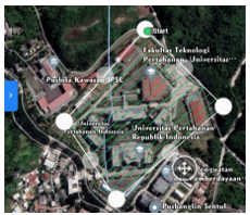
The development of technology in the 21st century is unstoppable. Indonesia must be able to gradually become independent in the field of defense technology. Presidential Decree No. 8 of 2021, one of the priority defense systems development programs is the development of Unmanned Combat Aircraft in which one of the types is drones. The purpose of this study is to design an IOT Drone for mapping the IPSC Sentul area as the center of peace and security in Indonesia. The results of the study in the form of a three-dimensional model of The Republic of Indonesia Defense University area that were further compiled could be used for several national interests as well as conducting visual analysis in the area. The development of this research has several updates, namely the object of mapping research in the IPSC Sentul Area, Bogor. The results of the research are that commercial drones are designed and added with an Internet of Things (IoT) system so that they can do 2-dimensional and 3-dimensional mapping. Mapping requires internet which can connect the drone with at least 3 GPS satellites. Once connected successfully, it is possible to create waypoints or mapping paths. The next result is a two-dimensional and three-dimensional mapping. The results of the two-dimensional mapping can be seen in Figure 5. The results are processed using agisoft metashape to produce a three-dimensional map. The three-dimensional map can be seen in Figure 6.
Downloads
References
Hidayat, R., Muhaimin., & Aidi, F.(2019). Rancang Bangun Prototype Drone Penyemprot Pestisida Untuk Pertanian Padi Secara Otomatis. Jurnal Tektro, 3(2), 86-94.
Ilic, D., & Vladimir, T. (2021). The Impact of The Nagorno-Karabakh Conflict in 2020 on The Perception of Combat Drones. Journal of Engineering Management,6(1).
Kristian, W; Mussadun. 2013. Penentuan Tipologi KDB dan KDH pada Perumahan Dengan Topografi Perbukitan (Studi Kasus: Kelurahan Gedawang Kota Semarang). Jurnal Ruang. Vol.1 Hal.141-150
Pratama, B. M., Gunawan, D., & Gultom, R. A. G. (2020). Deep learning-based object detection and geographic coordinate estimation system for GeoTiff imagery. In Journal of Physics: Conference Series (Vol. 1577, No. 1, p. 012003). IOP Publishing.
Respati, R.E., & Irwansyah, I. (2020). "Smart Flight" sebagai Bentuk Pelatihan Pilot Drone oleh Pasukan Drone Bogor Indonesia. Jurnal Komunikasi, 14(1), 1-14.
Saputra, D.R.H., & Bambang. P. (2013). Rancang Bangun Prototype Unmanned Aerial Vehicle (UAV) dengan Tiga Rotor. Jurnal Teknik Pomits, 2(1), 47-52
Susdarwono, E.T. (2021). Artificial Intelligence (AI) Drone dalam Pertahanan: Problem dan Kemajuan. Jurnal Ilmiah Intech Information Technology Journal of UMUS, 3(1), 1-11.
Syam, T, et al. 2012. Pemanfaatan Citra Satelit dalam Mengidentifikasi Perubahan Penutupan Lahan: Studi Kasus Hutan Lindung Register 22 Way Waya Lampung Tengah. Globe Vol 14 No.2 Desember 2012: 146-156
Voskuijil, M. (2021). Performance analysis and design of loitering munitions: A comprehensive technical survey of recent developments. Jurnal Defense Technology. 1-19
Wijaya, A; Susetyo, C. 2017. Analisis Perubahan Penggunaan Lahan di Kota Pekalongan Tahun 2003, 2009, dan 2016. Jurnal Teknik ITS. Vol.6 No.2
Downloads
Published
How to Cite
Issue
Section
License

This work is licensed under a Creative Commons Attribution-ShareAlike 4.0 International License.
All papers should be submitted electronically. All submitted manuscripts must be original work that is not under submission at another journal or under consideration for publication in another form, such as a monograph or chapter of a book. Authors of submitted papers are obligated not to submit their paper for publication elsewhere until an editorial decision is rendered on their submission. Further, authors of accepted papers are prohibited from publishing the results in other publications that appear before the paper is published in the Journal unless they receive approval for doing so from the Editor-In-Chief.
IJISAE open access articles are licensed under a Creative Commons Attribution-ShareAlike 4.0 International License. This license lets the audience to give appropriate credit, provide a link to the license, and indicate if changes were made and if they remix, transform, or build upon the material, they must distribute contributions under the same license as the original.


