
Bigdata Based Disaster Monitoring of Satellite Image Processing Using Progressive Image Classification Algorithm
Keywords:
Intermittent Image Clustering Segmentation, Progressive Image Classification Algorithm, Satellite Image, Disaster DetectionAbstract
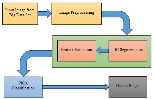
The analysis of remote sensing image areas is a need for climate detection and management to monitor flood disasters in key environments and applications. The satellite image is most used to detect the disaster analysis in the earth, and it has advantages to capture an earth image, this earth image has more information to give the control technique. Since the acquisition of satellite and aerial imagery, this system detects the flood disaster, and flood detection has become more desirable in recent years with increasing convenience. In this research work, Progressive Image Classification Algorithm (PICA) is proposed to detect the earth disaster and classify the result more effectively. PICA is most essential to overcome robust shadows, proper access to the characteristics of the disaster, false positives by operators, or false that affect the impact of the disaster. It creates tailoring and adjustments obtained from satellite images before training and post-disaster aerial image data patches. The proposed PICA detects the earth disaster earlier and the accuracy (95.96%).
Downloads
References
Guichen Zhang, Pedram Ghamisi, “Fusion of Heterogeneous Earth Observation Data for the Classification of Local Climate Zones” in IEEE Trans on Geoscience and Remote Sensing, Volume. 57, issue. 10, page. 7623 – 7642, 2019.
Xiaochong Tong, Jing Wang, “Normalized Projection Models for Geostationary Remote Sensing Satellite: A Comprehensive Comparative Analysis” in IEEE Trans on geoscience and remote sensing, Volume. 57, issue. 10, page. 7623 – 7642, 2019.
Zhengyang Lin, Fang Chen, “A Contextual and Multi-temporal Active-Fire Detection Algorithm Based on FengYun-2G S-VISSR Data” in IEEE Trans on geoscience and remote sensing, Volume. 57, issue. 11, page. 8840 – 8852, 2019.
Anusha, Bharathi, “An overview on Change Detection and a Case Study Using Multi-temporal Satellite Imagery” in International Conf on Computational Intelligence in Data Science, 2019.
Franz J Meyer, Olaniyi A Ajadi, “Applications of a SAR-Based Flood Monitoring Service during Disaster Response and Recovery” in International Geoscience and Remote Sensing Symposium, 2019.
Boris Bergues, Matthias Kubel, "Single-Cycle Non-Sequential Double Ionization" in the IEEE Journal of selected topics in quantum electronics, Volume. 21, issue. 5, 2019.
Caglayan Tuna, Merciol, “Monitoring Urban Growth with Spatial Filtering of Satellite Image Time Series” in Joint Urban Remote Sensing Event, 2019.
Lalitha, Shanta Rangaswamy, “Satellite Image Enhancement Using Neural Networks” in International Conf on Inventive Computation Technologies, 2018.
Edgardo Lozano-Cotrina, Erik Berrospi-Elises, “Detection of Minerals Through the Processing of Satellite Images” in International Conf on Electronics, Electrical Engineering, and Computing, 2018.
Risa UMEMURA, Toshikazu SAMURA, “An efficient orthorectification of a satellite SAR image used for monitoring disaster" in International Workshop on Advanced Image Technology, 2018.
Haopeng Zhang, Yi Su, "Star Image Simulation and Subpixel Centroiding for an Earth Observing Sensor” in International Geoscience and Remote Sensing Symposium, 2018.
Masato Ohki, Masanobu Shimada, “Large-Area Land Use and Land Cover Classification with Quad, Compact, and Dual Polarization SAR Data by PALSAR-2” in IEEE Trans on geoscience and remote sensing, Volume. 58, issue. 9, page. 5550 – 5557, 2018.
Dalgeun Lee, Jongpil Kim, “Application of Landsat-8 and Sentinel-1 Images for Drought Monitoring Over the Korean Peninsula” in International Geoscience and Remote Sensing Symposium, 2018.
Li, LU, “Application of the GF satellite data in flood disaster monitoring” in International Geoscience and Remote Sensing Symposium, 2018.
Jianghao Sun, Lin Yuan, “Regional-scale monitoring of rice flood disaster based on multi-temporal remote sensing images” in International Conf on Agro-geo-informatics, 2018.
Wei Wu, Wei Liu, “Remote sensing recognition of residential areas based on GF-4 satellite image” in International Workshop on Earth Observation and Remote Sensing Applications, 2018.
Salman, Xuming, “Forest Change Detection in Incomplete Satellite Images With Deep Neural Networks” in IEEE Trans on Geoscience and Remote Sensing, Volume. 55, issue. 9, page. 5407 – 5423, 2017.
Xuejun Zhai, Xiaonan Niu, “Distance Dependent Chinese Restaurant Process for VHR Satellite Image Over segmentation” in Joint Urban Remote Sensing Event, 2017.
Takeshi Motohka, Yukihiro Kankaku, “Advanced Land Observing Satellite-2 (ALOS 2) and its follow-on L-band SAR mission” in Radar Conference, 2017.
Shigenori Tani, Michiya Hayama, “Multi-carrier Relaying for Successive Data Transfer in Earth Observation Satellite Constellations” in Global Communications Conference, 2017.
Xiaodong Li, Feng Ling, "A Super-resolution Land-Cover Change Detection Method Using Remotely Sensed Images With Different Spatial Resolutions" in IEEE Trans on geoscience and remote sensing, Volume. 54, issue. 7, page. 3822 – 3841, 2016.
Downloads
Published
How to Cite
Issue
Section
License

This work is licensed under a Creative Commons Attribution-ShareAlike 4.0 International License.
All papers should be submitted electronically. All submitted manuscripts must be original work that is not under submission at another journal or under consideration for publication in another form, such as a monograph or chapter of a book. Authors of submitted papers are obligated not to submit their paper for publication elsewhere until an editorial decision is rendered on their submission. Further, authors of accepted papers are prohibited from publishing the results in other publications that appear before the paper is published in the Journal unless they receive approval for doing so from the Editor-In-Chief.
IJISAE open access articles are licensed under a Creative Commons Attribution-ShareAlike 4.0 International License. This license lets the audience to give appropriate credit, provide a link to the license, and indicate if changes were made and if they remix, transform, or build upon the material, they must distribute contributions under the same license as the original.


