
Mapping of Top-Soil Salinity Zoning in the Coastal Area of Ben Tre Province, Vietnam
Keywords:
: Top-soil salinity, EC, Landsat 8, Bayesian statistic, multivariable linear regressionAbstract
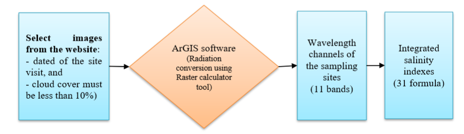
The study is aimed to construction of top-soil salinity maps for three coastal districts of Ben Tre province, which is one of the Mekong Delta areas that have been seriously affected by saline intrusion in recent years. A total of 124 top-soil samples were collected and analyzed during the dry season in 2021, of which 59 and 65 samples were taken in January and March respectively. Multivariable linear regression model was then built based on measured salinity, by Electrical Conductivity parameter, and spectral bands extracted from Landsat 8 satellite images for the respective days. The model was built based on the Bayesian statistical method, processed by the R statistical program (version 4.0.3), which big difference between Bayesian and classical statistical methods is that this method does not need to evaluate the distribution of the inputs, therefore helping to optimize the quality and quantity of the collected dataset. The results of the model showed that the model efficiency reaches 67%, and the RMSE and IOA validation parameters meet the requirements: 1.31 and 0.63 respectively. The model also showed that the infrared and panchromatic spectral bands are the two spectral bands which are capable of predicting the salinity of the topsoil in this area. Therefore, the results of this study contribute to a potential method in building an effective and low-cost model to assess surface soil salinity in the study area.
Downloads
References
Akramkhanov, A., Vlek, P.L.G., 2012. The assessment of spatial distribution of soil salinity risk using neural network. Environ. Monit. Assess. 184, 2475–2485. https://doi-org/10.1007/s10661-011-2132-5
Allbed, A., Kumar, L., Sinha, P., 2014. Mapping and Modelling Spatial Variation in Soil Salinity in the Al Hassa Oasis Based on Remote Sensing Indicators and Regression Techniques. Remote Sens. 6, 1137–1157. https://doi-org/10.3390/rs6021137.
Adeeb, H.Q., Al-Timiti, Y.K., 2021. Change on detection of vegetation cover and soil salinity using GIS technique in Diyala Governorate, Iraq. Sci. Rev. Eng. Environ. Sci. 30 (1), 148–158. Error! Hyperlink reference not valid..
Bannari, A., Al-Ali, Z.M., 2020. Assessing Climate Change Impact on Soil Salinity Dynamics between 1987–2017 in Arid Landscape Using Landsat TM, ETM+ and OLI Data. Remote Sens. 12, 2794. https://doi-org /10.3390/rs12172794.
Bouaziz, M., Matschullat, J.; Gloaguen, R., 2011. Improved remote sensing detection of soil salinity from a semi-arid climate in Northeast Brazil. C.R. Geosci. 343, 795–803. https://doi.org/10.1016/j.crte.2011.09.003.
Bhat, M.A., Sheoran, H.S., Dar, E.A., Dahiya, H.S., Wani, S.A., Singh, I., Sing, S., 2015. Geoinformatics as a Tool for Appraisal of Salt-Affected Soils-A Review. Int. J. Innovative Sci. Eng. Technol. 2 (10), 480–490.
CGIAR Research Program on Climate Change, Agriculture and Food Security- Southeast Asia (CCAFS-SEA). 2016. Assessment Report: The drought and salinity intrusion in the Mekong River Delta of Vietnam. Hanoi, Vietnam.
Diana, P.S., Heruna, T., 2018. Linear regression model using bayesian approach for energy performance of residential building. Procedia Comput. Sci. 135, 671–677.
Ding, J., Yang, S., Shi, Q., Wei, Y., Wang, F., 2020. Using Apparent Electrical Conductivity as Indicator for Investigating Potential Spatial Variation of Soil Salinity across Seven Oases along Tarim River in Southern Xinjiang, China. Remote Sens. 12, 2601. Error! Hyperlink reference not valid..
El Hafyani, M., Essahlaoui, A., El Baghdadi, M., Teodoro, A.C., Mohajane, M., El hmaidi, A., El ouali, A., 2019. Modeling and mapping of soil salinity in Tafilalet plain (Morocco). Arabian J. Geosci. 12, 35. https://doi.org/10.1007/s12517-018-4202-2.
Fei, Y.H., She, D.L., Yao, Z.D., Li, L., Ding, J.H.; Hu, W., 2017. Hierarchical Bayesian models for predicting soil salinity and sodicity characteristics in a coastal reclamation region. Ecol. Eng. 104, 45–56. https://doi.org/10.1016/j.ecoleng.2017.04.006.
Fornacon-Wood, I., Mistry, H., Johnson-Hart, C., Faivre-Finn, C., O'Connor, J.P. B., Price, G.J., 2022. Understanding the Differences Between Bayesian and Frequentist Statistics. Int. J. Radiat. Oncol. Biol. Phys. 112, 1076–1082. https://doi.org/10.1016/j.ijrobp.2021.12.011.
Fragoso, T.M., Bertoli, W.; Louzada, F., 2018. Bayesian Model Averaging: A Systematic Review and Conceptual Classification. Int. Stat. Rev. 86, 1–28. https://doi.org/10.1111/insr.12243.
Fourati, H.T., Bouaziz, M., Benzina, M., Bouaziz, S., 2017. Detection of terrain indices related to soil salinity and mapping salt-affected soils using remote sensing and geostatistical techniques. Environ. Monit. Assess. 189, 177. https:// doi.org/10.1007/s10661-017-5877-7.
Fan, X., Liu, Y., Tao, J., Weng, Y., 2015. Soil Salinity Retrieval from Advanced Multi-Spectral Sensor with Partial Least Square Regression. Remote Sens. 7, 488–511. https://doi.org/10.3390/rs70100488.
Judkins, G., Myint, S., 2012. Spatial Variation of Soil Salinity in the Mexicali Valley, Mexico:Application of a Practical Method for Agricultural Monitoring. Environ. Manage. 50, 478–489. https://doi.org /10.1007/s00267-012-9889-3.
Gao, B.C., 1996. NDWI—A normalized difference water index for remote sensing of vegetation liquid water from space. Remote Sens. Environ. 58 (3), 257–266. https://doi.org/10.1016/S0034-4257(96)00067-3.
Gorji, T., Sertel, E., Tanik, A., 2017. Recent satellite technologies for soil salinity assessment with special focus on Mediterranean countries. Fresenius Environ. Bull. 26 (1), 196–203.
Gorji, T., Sertel, E., Tanik, A., 2017. Monitoring soil salinity via remote sensing technology under data scarce conditions: A case study from Turkey. Ecol. Indic. 74, 384–391. https://doi.org/10.1016/j.ecolind.2016.11.043.
Ghazavi, R., Pakparvar, M., 2018. Mapping spatial variability of soil salinity in a coastal area located in an arid environment using geostatistical and correlation methods based on the satellite data. Desert 23-2, 233-242. Avaiable Online: http://desert.ut.ac.ir.
Guo, B., Han, B., Yang, F., Fan, Y., Jiang, L., Chen, S., Yang, W., Gong, R., Liang, T., 2019. Salinization information extraction model based on VI–SI feature space combinations in the Yellow River Delta based on Landsat 8 OLI image. Geomatics Nat. Hazards Risk 10 (1), 1863–1878. https://doi.org/10.1080/19475705.2019.1650125.
Hasab, H.A., Dibs, H., Dawood, A.S., Hadi, W.H., Hussain, H.M., Al-Ansari, N., 2020. Monitoring and Assessment of Salinity and Chemicals in Agricultural Lands by a Remote Sensing Technique and Soil Moisture with Chemical Index Models. Geosciences 10, 207. Error! Hyperlink reference not valid..
Hu, J., Peng, J., Zhou, Y., Xu, D., Zhao, R., Jiang, Q., Fu, T., Wang, F., Zhou Shi, Z., 2019. Quantitative Estimation of Soil Salinity Using UAV-Borne Hyperspectral and Satellite Multispectral Images. Remote Sens. 11, 736. https://doi-org/10.3390/rs11070736.
Hoa, P.V., Giang, N.V., Binh, N.A., Hai, L.V.H., Pham, T.D., Hasanlou, M., Bui, D.T., 2019. Soil Salinity Mapping Using SAR Sentinel-1 Data and Advanced Machine Learning Algorithms: A Case Study at Ben Tre Province of the Mekong River Delta (Vietnam). Remote Sens. 11, 128. https://doi-org/10.3390/rs11020128.
Ijaz, M., Ahmad, H.R., Bibi, S., Ayub, M.A., Khalid, S., 2020. Soil salinity detection and monitoring using Landsat data: a case study from Kot Addu, Pakistan. Arabian J. Geosci. 13, 510. https://doi.org/10.1007/s12517-020-05572-8.
Judkins, G., Myint, S., 2012. Spatial Variation of Soil Salinity in the Mexicali Valley, Mexico: Application of a Practical Method for Agricultural Monitoring. Environ. Manage. 50, 478–489. https://doi.org /10.1007/s00267-012-9889-3.
Kurbatova, A.I., Bouchhima, R.A., Grigorets, E.A. et al., 2021. Methodology for mapping soil salinity and halophyte cover using remote sensing data in Kerkennah, Tunisia. Euro-Mediterr J. Environ. Integr. 6, 51. Error! Hyperlink reference not valid..
Kauth, R.J., Thomas, G.S., 1976. The Tasselled Cap - A Graphic Description of the Spectral-Temporal Development of Agricultural Crops as Seen by LANDSAT. LARS Symp. 159. http://docs.lib.purdue.edu/lars_symp/159.
Lopez Puga, J., Krzywinski, M., Altman, N., 2015. Points of significance: Bayesian statistics. Nat. Methods 12, 377–378. https://doi.org/10.1038/nmeth.3368.
Lhissou, R., El Harti, A., Chokmani, K., 2014. Mapping Soil Salinity in Irrigated Land Using Optical Remote Sensing Data. Eurasian J. of Soil Sci. 3, 82–88. https://doi-org/10.18393/ejss.84540.
Matinfar, H.R., Panah, S.K.A., Zand, F., Kamal Khodaei, K., 2013. Detection of soil salinity changes and mapping land cover types based upon remotely sensed data. Arab. J. Geosci. 6, 913–919. https://doi.org/10.1007/s12517-011-0384-6.
Meyer, L.H., Heurich, M., Beudert, B., Premier, J., Pflugmacher, D., 2019. Supplementary Materials: Comparison Between Landsat-8 and Sentinel-2 Data for Estimation of Leaf Area Index in Temperate Forests. Remote Sens. 11,1160. https://10.3390/rs11101160.
Ngo, D., Ha, N.T.T., Dang, Q.T., Koike, K., Trong, N.M., 2019. Effective Band Ratio of Landsat 8 Images Based on VNIR-SWIR Reflectance Spectra of Topsoils for Soil Moisture Mapping in a Tropical Region. Remote Sens. 11, 716. Error! Hyperlink reference not valid..
Nouri, H., Borujeni, S.C., Alaghmand, S., Anderson, S.J., Sutton, P.C., Parvazian, S., Beecham, S., 2018. Soil Salinity Mapping of Urban Greenery Using Remote Sensing and Proximal Sensing Techniques; The Case of Veale Gardens within the Adelaide Parklands. Sustainability 10, 2826. https://doi.org 10.3390/su10082826.
Nguyen, K.A., Liou, Y.A., Tran, H.P., Hoang, P.P., Nguyen, T.H., 2020. Soil salinity assessment by using near-infrared channel and Vegetation Soil Salinity Index derived from Landsat 8 OLI data: a case study in the Tra Vinh Province, Mekong Delta, Vietnam. Prog. Earth Planet. Sci. 7, 1. https://doi.org/10.1186/s40645-019-0311-0.
Nawar, S., Buddenbaum, H., Hill, J., Kozak, J., 2014. Modeling and Mapping of Soil Salinity with Reflectance Spectroscopy and Landsat Data Using Two Quantitative Methods (PLSR and MARS). Remote Sens. 6, 10813–10834. https://doi.org /10.3390/rs61110813.
Qian, T., Tsunekawa, A., Peng, F. et al., 2019. Derivation of salt content in salinized soil from hyperspectral reflectance data: A case study at Minqin Oasis, Northwest China. J. Arid Land 11, 111–122. https://doi-org /10.1007/s40333-019-0091-9.
Raftery, A.E., 1995. Bayesian model selection in social research. Sociological Method. 25 (25), 111–163. https://doi.org/10.2307/271063
Richards, L.A. (ed.) 1954. Diagnosis and improvements of saline and alkali soils. USDA. Agriculture Handbook 60. pp. 160.
Rubio, F.J. Genton, M.G., 2016. Bayesian linear regression with skew-symmetric error distributions with applications to survival analysis. Stat. Med. 35, 2441–2454. https://doi.org/10.1002/sim.6897.
Solangi, K.A., Siyal, A.A., Wu, Y., Abbasi, B., Solangi, F., Lakhiar, I.A., Zhou, G., 2019. An Assessment of the Spatial and Temporal Distribution of Soil Salinity in Combination with Field and Satellite Data: A Case Study in Sujawal District. Agronomy 9, 869. https://doi.org/10.3390/agronomy9120869.
Scudiero, E., Corwin, D.L., Anderson, R.G., Skaggs, T.H., 2016. Moving Forward on Remote Sensing of Soil Salinity at Regional Scale. Front. Environ. Sci. 4, 1–5. https://doi.org/10.3389/fenvs.2016.00065.
Sahbeni, G., 2021. Soil salinity mapping using Landsat 8 OLI data and regression modeling in the Great Hungarian Plain. SN Appl. Sci. 3, 587. https://doi.org/10.1007/s42452-021-04587-4.
Sahana, M., Rehman, S., Patel, P.P., Dou, J., Hong, H., Sajjad, H., 2020. Assessing the degree of soil salinity in the Indian Sundarban Biosphere Reserve using measured soil electrical conductivity and remote sensing data–derived salinity indices. Arabian J. Geosci. 13, 1289. https://doi.org/10.1007/s12517-020-06310-w.
Samra, R.M.A., Ali, R.R., 2018. The development of an overlay model to predict soil salinity risks by using remote sensing and GIS techniques: a case study in soils around Idku Lake, Egypt. Environ. Monit. Assess. 190, 706. https://doi.org/10.1007/s10661-018-7079-3.
Shahid, S.A., Abdelfattah, M.A., Omar, S.A.S., Harahsheh, H., Othman, Y., Mahmoudi, H., 2010. Mapping and Monitoring of Soil Salinization Remote Sensing, GIS, Modeling, Electromagnetic Induction and Conventional Methods – Case Studies. Proceedings of the International Conference on Soils and Groundwater Salinization in Arid Countries, 59-97. Sultan Qaboos University.
Shahrayini, E., Noroozi, A.A., 2022. Modeling and Mapping of Soil Salinity and Alkalinity Using Remote Sensing Data and Topographic Factors: a Case Study in Iran. Environ. Model. Assess. https://doi.org/10.1007/s10666-022-09823-8.
Sultanov, M., Ibrakhimov, M., Akramkhanov, A. et al., 2018. Modelling End-of-Season Soil Salinity in Irrigated Agriculture Through Multi-temporal Optical Remote Sensing, Environmental Parameters, and In Situ Information. PFG- J. Photogramm. Remote Sens. Geoinf. Sci. 86, 221–233. https://doi-org /10.1007/s41064-019-00062-3.
Taghadosi, M.M., Hasanlou, M., Eftekhari, K.., 2019. Retrieval of soil salinity from Sentinel-2 multispectral imagery. Eur. J. Remote Sens. 52 (1), 138–154. https://doi.org/10.1080/22797254.2019.1571870.
Taghadosi, M.M., Hasanlou, M., 2021. Developing geographic weighted regression (GWR) technique for monitoring soil salinity using sentinel 2 multispectral imagery. Environ. Earth Sci. 80, 75. https://doi.org/10.1007/s12665-020-09345-0.
Thiam, S., Villamor, G.B., Faye, L.C., Sène, J.H.B., Diwediga, B., Kyei Baffour, N., 2021. Monitoring land use and soil salinity changes in coastal landscape: a case study from Senegal. Environ. Monit. Assess. 193, 259. https://doi.org/10.1007/s10661-021-08958-7.
Vietnam Ministry of Science, Technology and Environment. 2000. Vietnam Standard TCVN 6650:2000 Soil quality - Determination of water-soluble and acid-soluble sulfate.
Vietnam National Administration of Science and Technology Information. 2016. Salinity intrusion in Cuu Long Delta: Causes, Impacts and Responses.
Wang, F., Chen, X., Luo, G. et al., 2013. Detecting soil salinity with arid fraction integrated index and salinity index in feature space using Landsat TM imagery. J. Arid Land 5, 340–353. https://doi-org /10.1007/s40333-013-0183-x.
Willmott, C.J., Robeson, S.M., Kenji, M., 2012. A refined index of model performance. Int. J. Climatol. 32, 2088–2094.
Wang, N., Xue, J., Peng, J., Biswas, A., He, Y., Zhou Shi, Z., 2020. Integrating Remote Sensing and Landscape Characteristics to Estimate Soil Salinity Using Machine Learning Methods: A Case Study from Southern Xinjiang, China. Remote Sens. 12, 4118. https://doi-org/10.3390/rs12244118.
Wang, J., Ding, J., Yu, D., Teng, D., He, B., Chen, X., Ge, X., Zhan, Z., Wang, Y., Yang, X., Shi, T., Su, F., 2019. Machine learning-based detection of soil salinity in an arid desert region, Northwest China: A comparison between Landsat-8 OLI and Sentinel-2 MSI. Sci. Total Environ. 707, 136092. https://doi.org/10.1016/j.scitotenv.2019.136092.
Yahiaoui, I., Douaoui, A., Zhang, Q. et al., 2015. Soil salinity prediction in the Lower Cheliff plain (Algeria) based on remote sensing and topographic feature analysis. J. Arid Land 7, 794–805. https://doi.org/10.1007/s40333-015-0053-9.
Yang, L., Huang, C., Liu, G. et al., 2015. Mapping soil salinity using a similarity-based prediction approach: A case study in Huanghe River Delta, China. Chin. Geogr. Sci. 25, 283–294. https://doi.org/10.1007/s11769-015-0740-7.
Downloads
Published
How to Cite
Issue
Section
License

This work is licensed under a Creative Commons Attribution-ShareAlike 4.0 International License.
All papers should be submitted electronically. All submitted manuscripts must be original work that is not under submission at another journal or under consideration for publication in another form, such as a monograph or chapter of a book. Authors of submitted papers are obligated not to submit their paper for publication elsewhere until an editorial decision is rendered on their submission. Further, authors of accepted papers are prohibited from publishing the results in other publications that appear before the paper is published in the Journal unless they receive approval for doing so from the Editor-In-Chief.
IJISAE open access articles are licensed under a Creative Commons Attribution-ShareAlike 4.0 International License. This license lets the audience to give appropriate credit, provide a link to the license, and indicate if changes were made and if they remix, transform, or build upon the material, they must distribute contributions under the same license as the original.


