
Classification Performance of Land Use from Multispectral Remote Sensing Images using Decision Tree, K-Nearest Neighbor, Random Forest and Support Vector Machine Using EuroSAT Data
Keywords:
machine learning algorithm, land use/land cover (LULC), decision tree, k-nearest neighbor, support vector machine, random forestAbstract
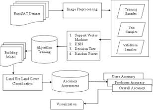
Remote sensing is commonly used in remote sensing applications for land cover and land use classification using remotely sensed data. Different algorithms for LULC mapping need to be compared to determine which one is most accurate for further use of Earth observations. In this study, performance of four machine learning algorithms, specifically decision tree (DT), k-nearest neighbor (KNN), support vector machine (SVM), and random forest (RF) was examined with the help of satellite images from the EuroSAT dataset. Accuracy assessment was performed using the training, testing, and validation methods. With the help of the confusion matrix, the classification output, the prediction test, and validation accuracy assessment were assessed to obtain the classifier with more accuracy. Validating the classification findings against actual data would reveal the optimal performance. According to the EuroSAT dataset, the overall classification accuracy was 98.57 percent, which is higher than the K-nearest neighbor classifier and more suitable for satellite image classification. Appropriate LULC maps can be produced by accurately classifying the data. This map can be used in variety of applications. Based on Sentinel-2 satellite photos, we provide a new dataset with 27,000 classified images from 13 spectral bands and 10 classifications. The suggested research's categorization approach opens the door to an extensive range of Earth observation applications. Maps may be improved by using a categorized system, which we illustrate here.
Downloads
References
S. E. Franklin “Remote Sensing for Sustainable Forest Management”. New York. Lewis Publishers, 2001.
A. De Sherbinin “Land use and land cover change” in 4 A CLESIN Thematic Guides, Palisades, YN. Centre for International Earth Science Information Network of Columbia University. 2002, pp. 67.
Dean, A.M and Smith, G.M. “An evaluation of per – parcel land cover mapping using maximum likelihood class probabilities” in International Journal of Remote Sensing, 24 (14), 2905-2920, 2003.
EuroSAT: A novel dataset and deep learning benchmark for land use and land cover classification. Patrick Helber, Benjamin Bischke, Andreas Dengel, Damian Borth. IEEE Journal of Selected Topics in Applied Earth Observations and Remote Sensing, 2019.
Introducing EuroSAT: A Novel Dataset and Deep Learning Benchmark for Land Use and Land Cover Classification. Patrick Helber, Benjamin Bischke, Andreas Dengel. 2018 IEEE International Geoscience and Remote Sensing Symposium, 2018.
Anusha, D. J. ., R. . Anandan, and P. V. . Krishna. “Modified Context Aware Middleware Architecture for Precision Agriculture”. International Journal on Recent and Innovation Trends in Computing and Communication, vol. 10, no. 7, July 2022, pp. 112-20, doi:10.17762/ijritcc.v10i7.5635.
M. Seetha, I. V. Muralikrishna “Artificial neural network and other methods of image classification” in Journal of theoretical and Applied Information Technology.
Geospatial Innovation Facilities in Center for Biodiversity and Conservation.
Cortes, C., and V. Vapnik. 1995. “Support-vector Networks.” Machine Learning 20 (3): 273–297. doi:10.1007/bf00994018.
Vapnik, V. 1982. Estimation of Dependences Based on Empirical Data: Springer Series in Statistics (springer Series in Statistics). New York, NY: Springer-Verlag.
Mountrakis, G., I. Jungho, and C. Ogole. 2011. “Support Vector Machines in Remote Sensing: A Review.” ISPRS Journal of Photogrammetry and Remote Sensing 66 (3): 247–259. doi:10.1016/j.isprsjprs.2010.11.001.
Ravita, R., & Rathi, S. (2022). Inductive Learning Approach in Job Recommendation. International Journal of Intelligent Systems and Applications in Engineering, 10(2), 242–251. Retrieved from https://ijisae.org/index.php/IJISAE/article/view/1829
Breiman, L. 2001. “Random Forests.” Machine Learning 45 (1): 5–32. doi:10.1023/a:1010933404324.
Hastie, T., R. Tibshirani, and J. Friedman. 2009. “Random Forests.” In The Elements of Statistical Learning: Data Mining, Inference, and Prediction, 587–604. New York: Springer New York.
Altman, N.S., 1992. An introduction to kernel and nearest-neighbor nonparametric regression. The American Statistician, 46(3), pp.175-185.
Quinlan, J.R., 1986. Induction of decision trees. Machine learning, 1(1), pp.81-106.
Staff, I.,2017. Decision Tree. Investopedia. Retrieved 7 November 2017, from http://www.investopedia.com/terms/d/decision-tree.asp
Woznicki, S. A., J. Baynes, S. Panlasigui, M. Mehaffey, and A. Neale. 2019. “Development of a Spatially Complete Floodplain Map of the Conterminous United States Using Random Forest.” Science of the Total Environment 647: 942–953. doi:10.1016/j.scitotenv.2018.07.353.
Betts, M. G., W. J. Christopher Wolf, B. P. Ripple, K. A. Millers, S. H. Adam Duarte, M. Butchart, and T. Levi. 2017. “Global Forest Loss Disproportionately Erodes Biodiversity in Intact Landscapes.” Nature 547: 441. doi:10.1038/nature23285.
Araki, S., M. Shima, and K. Yamamoto. 2018. “Spatiotemporal Land Use Random Forest Model for Estimating Metropolitan NO2 Exposure in Japan.” Science of the Total Environment 634: 1269–1277. doi:10.1016/j. scitotenv.2018.03.324.
Rodriguez-Galiano, V. F., B. Ghimire, J. Rogan, M. Chica-Olmo, and J. P. Rigol-Sanchez. 2012. “An Assessment of the Effectiveness of a Random Forest Classifier for Land-cover Classification.” ISPRS Journal of Photogrammetry and Remote Sensing 67: 93–104. doi:10.1016/j.isprsjprs.2011.11.002.
Gupta, D. J. . (2022). A Study on Various Cloud Computing Technologies, Implementation Process, Categories and Application Use in Organisation. International Journal on Future Revolution in Computer Science &Amp; Communication Engineering, 8(1), 09–12. https://doi.org/10.17762/ijfrcsce.v8i1.2064
Wu, L.; Zhu, X.; Lawes, R.; Dunkerley, D.; Zhang, H. Comparison of machine learning algorithms for classification of LiDAR points for characterization of canola canopy structure. Int. J. Remote Sens. 2019, 40, 5973–5991.
Aaron E. Maxwell, Timothy A. Warner & Fang Fang (2018) Implementation of machine-learning classification in remote sensing: an applied review, International Journal of Remote Sensing, 39:9, 2784-2817, DOI: 10.1080/01431161.2018.1433343
Geospatial Innovation Facilities in Center for Biodiversity and Conservation.
Sally Fouad Shady. (2021). Approaches to Teaching a Biomaterials Laboratory Course Online. Journal of Online Engineering Education, 12(1), 01–05. Retrieved from http://onlineengineeringeducation.com/index.php/joee/article/view/43
Sultan AlSultan “Innovative Satellite Image Map Of R. Alkhabrta Area, Saudi Arabia Using High Resolution Image”, School of Physics.
Downloads
Published
How to Cite
Issue
Section
License

This work is licensed under a Creative Commons Attribution-ShareAlike 4.0 International License.
All papers should be submitted electronically. All submitted manuscripts must be original work that is not under submission at another journal or under consideration for publication in another form, such as a monograph or chapter of a book. Authors of submitted papers are obligated not to submit their paper for publication elsewhere until an editorial decision is rendered on their submission. Further, authors of accepted papers are prohibited from publishing the results in other publications that appear before the paper is published in the Journal unless they receive approval for doing so from the Editor-In-Chief.
IJISAE open access articles are licensed under a Creative Commons Attribution-ShareAlike 4.0 International License. This license lets the audience to give appropriate credit, provide a link to the license, and indicate if changes were made and if they remix, transform, or build upon the material, they must distribute contributions under the same license as the original.


