
Prediction of Population Density & Poverty Rate Using Uncertain Mosaics with Satellite Imagery
Keywords:
Random Forest, Satellite Imagery, Image encoding, CNN, Mosaic, Regression, SIMLAbstract
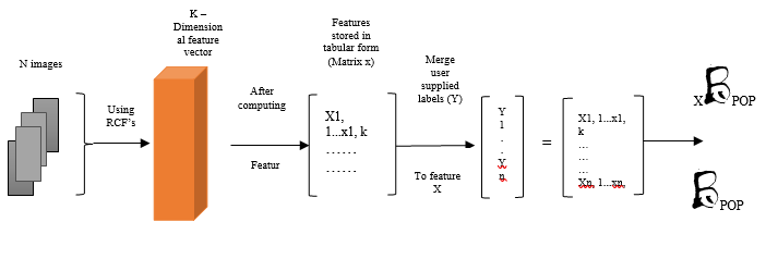
This research work involves combination of Random Forest optimization along with Satellite Imagery (SIML) which is having potential for addressing major global problems by remotely accessing socio-economic and meteorological conditions in data poor areas, although SIML’s resource requirements will limits its access and utilization. The Random Forest along with Satellite Imagery (SIML) is enabling better characterizations for population densities and poverty Rates. Further, this Random Forest Applications proves to be a path which is effective to convert such huge amount of uncertain image data into formed assess of conditions of ground.The satellite imagesare collected from GIS (Geographic information system) and then process collected images to RFO for removing mosaic with regression concept. This proposed model generates accuracy 98.78%, recall 97.34%, throughput 97.75% sensitivity 98.45% and efficiency 96.25%. The following outcomes has been competed with present technology and out performers the methodology.
Downloads
References
Panda, A., Singh, A., Kumar, K., Kumar, A., & Swetapadma, A. (2018, April). Land cover prediction from satellite imagery using machine learning techniques. In 2018 Second International Conference on Inventive Communication and Computational Technologies (ICICCT) (pp. 1403-1407). IEEE.
Pandey, S. M., Agarwal, T., & Krishnan, N. C. (2018, April). Multi-task deep learning for predicting poverty from satellite images. In Thirty-Second AAAI Conference on Artificial Intelligence.
Georganos, S., Grippa, T., Gadiaga, A., Vanhuysse, S., Kalogirou, S., Lennert, M., & Linard, C. (2019, May). An application of geographical random forests for population estimation in Dakar, Senegal using very-high-resolution satellite imagery. In 2019 Joint Urban Remote Sensing Event (JURSE) (pp. 1-4). IEEE.
Shahrin, F., Zahin, L., Rahman, R., Hossain, A. J., Kaf, A. H., & Azad, A. A. M. (2020, December). Agricultural analysis and crop yield prediction of habiganj using multispectral bands of satellite imagery with machine learning. In 2020 11th International Conference on Electrical and Computer Engineering (ICECE) (pp. 21-24). IEEE.
Liu, Y., Gong, W., Hu, X., & Gong, J. (2018). Forest type identification with random forest using Sentinel-1A, Sentinel-2A, multi-temporal Landsat-8 and DEM data. Remote Sensing, 10(6), 946.
Das, M. (2020, September). Online prediction of derived remote sensing image time series: An autonomous machine learning approach. In IGARSS 2020-2020 IEEE International Geoscience and Remote Sensing Symposium (pp. 1496-1499). IEEE.
Wu, T., Luo, J., Dong, W., Gao, L., Hu, X., Wu, Z., ... & Liu, J. (2020). Disaggregating county-level census data for population mapping using residential geo-objects with multisource geo-spatial data. IEEE Journal of Selected Topics in Applied Earth Observations and Remote Sensing, 13, 1189-1205.
Gebreegziabher, B. A. (2021). Mapping road pavement quality from optical satellite imagery using machine learning (Master's thesis, University of Twente).
Oughton, E. J., & Mathur, J. (2021). Predicting cell phone adoption metrics using machine learning and satellite imagery. Telematics and Informatics, 62, 101622.
Jarry, R., Chaumont, M., Berti-Équille, L., & Subsol, G. (2021, January). Assessment of CNN-based Methods for Poverty Estimation from Satellite Images. In International Conference on Pattern Recognition (pp. 550-565). Springer, Cham.
Nischal, K. N., Radhakrishnan, R., Mehta, S., & Chandani, S. (2015, March). Correlating night-time satellite images with poverty and other census data of India and estimating future trends. In Proceedings of the Second ACM IKDD Conference on Data Sciences (pp. 75-79).
Upadhyay, A., Upadhyay, A., & Maurya, S. (2017, September). Regression and artificial neural network based improved classification of LISS-III satellite image. In 2017 International Conference on Current Trends in Computer, Electrical, Electronics and Communication (CTCEEC) (pp. 917-921). IEEE.
Luo, H., & Liu, Y. (2017, November). A prediction method based on improved ridge regression. In 2017 8th IEEE International Conference on Software Engineering and Service Science (ICSESS) (pp. 596-599). IEEE.
Pandey, P., Dewangan, K. K., & Dewangan, D. K. (2017, April). Enhancing the quality of satellite images by preprocessing and contrast enhancement. In 2017 international conference on communication and signal processing (ICCSP) (pp. 0056-0060). IEEE.
Yuan, Z., & Tao, C. (2018, November). Estimation population density built on multilayer convolutional neural network. In 2018 5th International Conference on Systems and Informatics (ICSAI) (pp. 424-428). IEEE.
Kibria, B. G. (2003). Performance of some new ridge regression estimators. Communications in Statistics-Simulation and Computation, 32(2), 419-435.
Lin, C. Y., & Lin, C. (2019, July). Using ridge regression method to reduce estimation uncertainty in chlorophyll models based on worldview multispectral data. In IGARSS 2019-2019 IEEE International Geoscience and Remote Sensing Symposium (pp. 1777-1780). IEEE.
Li, T., Comer, M., & Zerubia, J. (2019, September). Feature extraction and tracking of CNN segmentations for improved road detection from satellite imagery. In 2019 IEEE International Conference on Image Processing (ICIP) (pp. 2641-2645). IEEE.
La, Y., Bagan, H., & Takeuchi, W. (2019, July). Explore urban population distribution using nighttime lights, land-use/land-cover and population census data. In IGARSS 2019-2019 IEEE International Geoscience and Remote Sensing Symposium (pp. 1554-1557). IEEE.
Jing, R., Gong, Z., & Guan, H. (2020). Land cover change detection with VHR satellite imagery based on multi-scale SLIC-CNN and SCAE features. IEEE Access, 8, 228070-228087.
Ayush, K., Uzkent, B., Burke, M., Lobell, D., & Ermon, S. (2020). Generating interpretable poverty maps using object detection in satellite images. arXiv preprint arXiv:2002.01612.
Ferreira, B., Iten, M., & Silva, R. G. (2020). Monitoring sustainable development by means of earth observation data and machine learning: A review. Environmental Sciences Europe, 32(1), 1-17.
Stratoulias, D., & Kabadayı, M. E. (2020). Land Cover Feature Extraction from Corona Spy Satellite Images during the Cold WAR-1968. In IGARSS 2020-2020 IEEE International Geoscience and Remote Sensing Symposium (pp. 6069-6072). IEEE.
Tsvetkovskaya, I. I., Tekutieva, N. V., Prokofeva, E. N., & Vostrikov, A. V. (2020, March). Methods of Obtaining Geospatial Data Using Satellite Communications and Their Processing Using Convolutional Neural Networks. In 2020 Moscow Workshop on Electronic and Networking Technologies (MWENT) (pp. 1-5). IEEE.
Jarry, R., Chaumont, M., Berti-Équille, L., & Subsol, G. (2021, January). Assessment of CNN-based Methods for Poverty Estimation from Satellite Images. In International Conference on Pattern Recognition (pp. 550-565). Springer, Cham.
Zhang, S., Nai, W., Qiu, Y., Xu, W., Yang, Z., Li, D., & Xing, Y. (2021, June). Ridge Regression Based on Glowworm Swarm Optimization Algorithm with t-Distribution Parameters. In 2021 IEEE 11th International Conference on Electronics Information and Emergency Communication (ICEIEC) 2021 IEEE 11th International Conference on Electronics Information and Emergency Communication (ICEIEC) (pp. 1-4). IEEE.
Keswani, M., Mahale, S., Kanwal, R., & Chopra, S. (2021, May). Land Cover Classification from Time Series Satellite Images. In 2021 2nd International Conference for Emerging Technology (INCET) (pp. 1-5). IEEE.
Huang, X., Zhu, D., Zhang, F., Liu, T., Li, X., & Zou, L. (2021). Sensing population distribution from satellite imagery via deep learning: Model selection, neighboring effects, and systematic biases. IEEE Journal of Selected Topics in Applied Earth Observations and Remote Sensing, 14, 5137-5151.
Gebreegziabher, B. A. (2021). Mapping road pavement quality from optical satellite imagery using machine learning (Master's thesis, University of Twente).
Koppula, N., Sarada, K., Patel, I., Aamani, R., & Saikumar, K. (2021). Identification and Recognition of Speaker Voice Using a Neural Network-Based Algorithm: Deep Learning. In Handbook of Research on Innovations and Applications of AI, IoT, and Cognitive Technologies (pp. 278-289). IGI Global.
Rao, K. S., Reddy, B. V., Sarada, K., & Saikumar, K. (2021). A Sequential Data Mining Technique for Identification of Fault Zone Using FACTS-Based Transmission. In Handbook of Research on Innovations and Applications of AI, IoT, and Cognitive Technologies (pp. 408-419). IGI Global.
Raju, K., Pilli, S. K., Kumar, G. S. S., Saikumar, K., & Jagan, B. O. L. (2019). Implementation of natural random forest machine learning methods on multi spectral image compression. Journal of Critical Reviews, 6(5), 265-273.
Garigipati, R. K., Raghu, K., & Saikumar, K. (2022). Detection and Identification of Employee Attrition Using a Machine Learning Algorithm. In Handbook of Research on Technologies and Systems for E-Collaboration During Global Crises (pp. 120-131). IGI Global.
Mythreya, S., Murthy, A. S. D., Saikumar, K., & Rajesh, V. (2022). Prediction and Prevention of Malicious URL Using ML and LR Techniques for Network Security: Machine Learning. In Handbook of Research on Technologies and Systems for E-Collaboration During Global Crises (pp. 302-315). IGI Global.
Saikumar, K., Rajesh, V., Babu, B.S. (2022). Heart disease detection based on feature fusion technique with augmented classification using deep learning technology. Traitement du Signal, Vol. 39, No. 1, pp. 31-42. https://doi.org/10.18280/ts.390104.
Downloads
Published
How to Cite
Issue
Section
License
Copyright (c) 2022 Jonnadula Prasanna, Mounika Susarla, K. Suvarna Vani, Harsha Vardhan Govada, Samuel Mories Mundru, M. S. R. Murthy

This work is licensed under a Creative Commons Attribution-ShareAlike 4.0 International License.
All papers should be submitted electronically. All submitted manuscripts must be original work that is not under submission at another journal or under consideration for publication in another form, such as a monograph or chapter of a book. Authors of submitted papers are obligated not to submit their paper for publication elsewhere until an editorial decision is rendered on their submission. Further, authors of accepted papers are prohibited from publishing the results in other publications that appear before the paper is published in the Journal unless they receive approval for doing so from the Editor-In-Chief.
IJISAE open access articles are licensed under a Creative Commons Attribution-ShareAlike 4.0 International License. This license lets the audience to give appropriate credit, provide a link to the license, and indicate if changes were made and if they remix, transform, or build upon the material, they must distribute contributions under the same license as the original.


