
A Comparative Study of Support Vector Machine and Maximum Likelihood Classification to Extract Land Cover of Wasit Governorate- Iraq
Keywords:
land cover, accuracy assessment, support vector machine, maximum likelihood classification, and kappa coefficientsAbstract
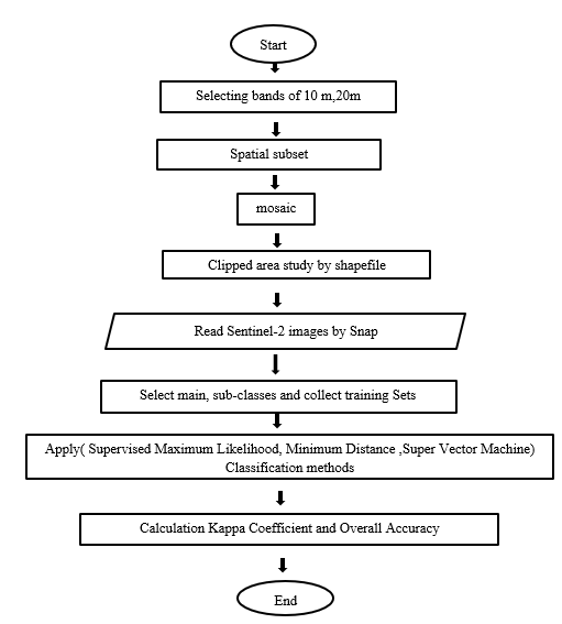
In order to effectively describe land cover, scientists, academics, and researchers developed machine learning classification algorithms. According to studies, these classification techniques perform better than more tried-and-true conventional techniques. The primary aim of this project is to determine the most effective strategy for categorizing land cover in order to retrieve data from Wasit. The Maximum Likelihood Classifier (MLC), which is based on the neighborhood function, and the Support Vector Machine (SVM), which is based on the ideal hyper-plane function, are two supervised classification techniques that are contrasted using Sentinel-2 data. Four land cover classes have been chosen for this optimization. Four spatial layers of the research region were surveyed with the aim of collecting and providing field-based training samples. The error matrix and kappa statistics have been used to evaluate the accuracy of each classifier. Results demonstrated that SVM performs superior to MLC. SVM and MLC have overall accuracies of 99.79 and 99.60%, respectively, and kappa coefficients of 0.997 and 0.994.
Downloads
References
Abdi, A.M. 2020. Land cover and land use classification performance of machine learning algorithms in a boreal landscape using Sentinel-2 data. GIScience & Remote Sensing, 57: 1-20. (https://doi.org/10.1080/15481603.2019.1650447 ) .
Brar, G.S. 2013. Detection of land use and land cover change with Remote sensing and GIS: A case study of Punjab Siwaliks. International Journal of Geomatics and Geosciences, 4: 296-304. (https:// www.semanticscholar.org/paper/Detection-of-landuse-and-land-cover-change-with-ABrar /1667abddcd5cb786cbb68543c26580f2d3555f20 ).
Census. 2017. Provisional summary results of 6th population and housing census-2017. Pakistan bureau of statistics. (http://www.pbs.gov.pk/content/provisional-summary-results-6th-population-andhousing-census-2017-0 ).
Chiemelu, N.E., Onwumere, V.O. 2013. Land information systems for efficient land administration and revenue generation: a case study of tans-amadi industrial layout. Port Harcourt, Nigeria, Journal of Information Engineering and Application, 3:13-23. (https://www.iiste.org/Journals/index.php/JIEA/article/view/8920) .
Chrysoulakis, N., Abrams, M., Feidas, H., Arai, K. 2010. Comparison of atmospheric correction methods using ASTER data for the area of Crete, Greece. International Journal of Remote Sensing, 31: 6347-6385. (https://www.researchgate.net/publication/253497600 ).
Cui, H.S. 2019. Sub-urban land classification using GF-2 images and support vector machine method. In:Proceedings of International Conference on Advances in Civil and Ecological Engineering Research, pp. 351 012028, Kaohsiung, Taiwan.( https://iopscience.iop.org/article/10.1088/1755-1315/351/1/012028/meta)
Gupta, M., Srivastava, P.K. 2010. Integrating GIS and remote sensing for identification of groundwater potential zones in the hilly terrain of Pavagarh, Gujarat, India. Water International, 35: 233-245. (https://www.tandfonline.com/doi/full/10.1080/02508061003664419 ).
Hütt, C., Koppe, W., Miao, Y., Bareth, G. 2016. Best accuracy land use/land cover (LULC) classification to derive crop types using multi-temporal, multisensor, and multi-polarization SAR satellite images.Remote Sensing, 8: 684. (https://doi.org/10.3390/rs8080684)
Ngo, K.D., Lechner, A.M., Vu, T.T. 2020. Land cover mapping of the Mekong delta to support natural resource management with multi-temporal Sentinel-1A synthetic aperture radar imagery. Remote Sensing Applications: Society and Environment,17: 100272. (https://doi.org/10.1016/j.rsase.2019.100272)
Nitze, I., Schulthess, U., Asche, H. 2012. Comparison of machine learning algorithms random forest, artificial neural network and support vector machine to maximum likelihood for supervised crop type classification. In: Proceedings of 4th GEOBIA, pp.35, Rio de Janeiro - Brazil. (https://www.researchgate.net/profile/Ingmar_Nitze/publication/275641579)
Olmanson, L.G., Bauer, M.E. 2017. Land cover classification of the lake of the woods/rainy river Basin by object-based image analysis of Landsat and lidar data. Lake and Reservoir Management,33: 335-346. (https://doi.org/10.1080/10402381.2017.1373171)
Otukei, J.R., Blaschke, T. 2010. Land cover change assessment using decision trees, support vector machines and maximum likelihood classification algorithms. International Journal of Applied Earth Observation and Geoinformation, 12: S27–S31. (https://doi.org/10.1016/j.jag.2009.11.002)
Puletti, N., Chianucci, F., Castaldi, C. 2018. Use of Sentinel-2 for forest classification in Mediterranean environments. Annals of Silvicultural Research,42: 32-38. (http://dx.doi.org/10.12899/asr-1463)
Riaz, O., Ghaffar, A., Butt, I. 2014. Modelling land use patterns of Lahore (Pakistan) using remote sensing and GIS. Global Journal of Science Frontier Research. Environment & Earth Science, 14: 24-30. (https://www.researchgate.net/profile/Omar_Riaz/publication/281741257)
Sajjad, S.H., Batool, R., Qadri, S.T., Shirazi, S.A., Shakrullah, K. 2015. The long-term variability in minimum and maximum temperature trends and heat island of Lahore city, Pakistan. Science International, 27: 1321-1325. (https://www.researchgate.net/profile/Sm_Talha_Qadri/publication/280802787 ).
Srivastava, P.K., Kiran, G., Gupta, M., Sharma, N., Prasad, K. 2012. A study on distribution of heavy metal contamination in the vegetables using GIS and analytical technique. International Journal of Ecology & Development, 21: 89-99. (http://www.ceserp.com/cp-jour/index.php/ijed/article/view/3936 ).
Szuster, B.W., Chen, Q. Borger, M.A. 2011.comparison of classification techniques to support land cover and land use analysis in tropical coastal zones. Applied Geography, 31: 525-532. (https://doi.org/10.1016/j.apgeog.2010.11.007)
Taati, A., Sarmadian, F., Mousavi, A., Pour, C.T.H., Shahir, A.H.E. 2015. Land use classification using support vector machine and maximum likelihood algorithms by Landsat 5 TM images. Walailak Journal of Science and Technology, 12: 681-687. (https://doi.nrct.go.th//ListDoi/listDetail?Resolve_DOI=10.14456/wjst.2015.33 )
Thanh N.P., Kappas, M. 2018. Comparison of random forest, k-nearest neighbor, and support vector machine classifiers for land cover classification using Sentinel-2 imagery. Sensors, 18:18. (https://doi.org/10.3390/s18010018 ).
Ustuner, M., Sanli, F.B., Dixon, B. 2015. Application of support vector machines for landuse classification using high-resolution RapidEye images: a sensitivity analysis. European Journal of Remote Sensing, 48:403-422. (https://doi.org/10.5721/EuJRS20154823 )
Vanonckelen, S., Lhermitte, S., Rompaey, A.V. 2013.The effect of atmospheric and topographic correction methods on land cover classification accuracy. International Journal of Applied Earth Observation and Geoinformation, 24: 9-21. (https://doi.org/10.1016/j.jag.2013.02.003 ).
Varma, M.K.S., Rao, N.K.K., Raju, K.K., Varma, G.P.S.2016. Pixel-based classification using support vector machine classifier. In: Proceedings of IEEE 6th International Conference on Advanced Computing, pp. 51-55, Bhimavaram, India (https://ieeexplore.ieee.org/abstract/document/7544809 )
Wulder, M.A., Coops, N.C., Roy, D.P., White, J.C., Hermosilla, T. 2018. Land cover 2.0. International Journal of Remote Sensing, 39: 4254-4284. (https://doi.org/10.1080/01431161.2018.1452075 ).
T. M. F. Al-Azzawi and A. A. S. Al-Zirgany, “Change Detection for Some Land Cover Types of Wasit Province ( Eastern Iraq ) Using Remote Sensing and GIS Techniques for Years 1989,” Indian J. Nat. Sci., vol. 9, no. 51, pp. 15359–15367, 2018.
R. I. M. Al-quraishi, “Environmental Geochemistry of Wasit Governorate, Iraq,” University of Baghdad, College of Science, Department of Geology, 2019.
D. S. Sha, “Land Use And Land Cover Classification And Change Detection Using Naip Imagery From 2009 To 2014 : Table Rock Lake Region , Missouri,” Geography, Geology and Planning, Missouri State University, 2016.
R. G. Congalton, “A review of assessing the accuracy of classifications of remotely sensed data,” Remote Sens. Environ., vol. 37, no. 1, pp. 35–46, 1991, doi: 10.1016/0034-4257(91)90048-B.
S. N. Sivanandam, S. Sumathi, and S. N. Deepa, Introduction to fuzzy logic using MATLAB. Springer-Verlag Berlin Heidelberg, 2007.
M. Sreelekha, “Accuracy Assessment of Supervised and Unsupervised Classification using NOAA Data in Andhra Pradesh Region,” Int. J. Eng. Res., vol. 8, no. 12, pp. 60–64, 2019, doi: 10.17577/ijertv8is120065.
Downloads
Published
How to Cite
Issue
Section
License

This work is licensed under a Creative Commons Attribution-ShareAlike 4.0 International License.
All papers should be submitted electronically. All submitted manuscripts must be original work that is not under submission at another journal or under consideration for publication in another form, such as a monograph or chapter of a book. Authors of submitted papers are obligated not to submit their paper for publication elsewhere until an editorial decision is rendered on their submission. Further, authors of accepted papers are prohibited from publishing the results in other publications that appear before the paper is published in the Journal unless they receive approval for doing so from the Editor-In-Chief.
IJISAE open access articles are licensed under a Creative Commons Attribution-ShareAlike 4.0 International License. This license lets the audience to give appropriate credit, provide a link to the license, and indicate if changes were made and if they remix, transform, or build upon the material, they must distribute contributions under the same license as the original.


